Tuesday 11 February 2014

Alien crayfish in the streams of the Wyre Forest: avoiding contamination

The stream-walking volunteers have had to be mindful of aliens: and no that doesn't mean the latest Doctor Who monster, but an alien species of crayfish that can cause problems for the native crayfish in the streams of the Wyre Forest.


White-clawed Crayfish
Atlantic Stream or white-clawed crayfish, courtesy Rosemary Winnall

The Atlantic Stream or white-clawed crayfish (Austropotamobius pallipes) is the native species of crayfish found in the British Isles. There has been a significant decline in native crayfish populations across England and Wales in recent years, and this has also been the case locally too. Much has been written about the local problem (see links below), and a major culprit for the decline is likely to be the invasion of local streams by an alien, or non-native crayfish, in particular the American Signal crayfish (Pacifastacus lenuisculus) which carries a disease (a fungal pathogen) which attacks the native crayfish.

Signal Crayfish
American signal crayfish, courtesy Rosemary Winnall
American Signal Crayfish, courtesy Rosemary Winnall

Volunteers have been advised to take precautions to avoid the spread of the pathogen. As the alien crayfish is found mainly in some of the tributaries, the Dowles and the Baveney Brooks, one of the precautions has been to stream-walk each brook and tributary separately to avoid stream-hopping. Stream-walking was, therefore, carried out separately by different volunteers for each watercourse. The fungal pathogen does not survive for long outside water, so washing waders and leaving them to dry before re-visiting any of the streams was also a precaution. Obviously, there is the potential for contamination to be innocently spread by members of the general public, but at least for the purposes of the survey, we can keep this likelihood to a minimum.

Our last post showed the photograph of the claws of an American Signal crayfish on the Baveney Brook (the remains, possibly, of an otter meal) taken by volunteer Terry, showing that the alien crayfish still lurk in that stream. Note the larger, broader claws, which are one of the traits differentiating the Signal crayfish from the native crayfish.

Thanks are due to Dr Graham Hill of Hills Ecology Ltd and Cody Levine of Worcestershire County Council for their advice. All images are courtesy of Rosemary Winnall of Wyre Forest Study Group.

By Liz Pearson
lpearson@worcestershire.gov.uk; Google+

Links


Dowles Brook Wyre Forest crayfish survey

Saturday 25 January 2014

Baveney Brook: through the Shropshire woodlands

The Baveney Brook flows through large expanses of woodland and coppice such as Maxfields Coppice, Malpass Wood and Coachroad Coppice. It is a narrow valley, often steep sided: the name 'Breakneck Bank' to the east of Malpass Wood speaks for itself. For centuries (from at least the 16th century), although remote and sparsely settled, small pockets of industry grew up along the banks of the streams around here. Small   ironstone mines in Neen Savage (in Malpass Wood) are known from medieval documents and a thin band of coal also runs along the Baveney Brook on the boundary with Kinlet. The Four Parishes Heritage Group has carried out research on the iron working industry in the area, and other aspects of local history.

Charcoal making has been a widespread industry in the Wyre Forest since medieval times, adding to the local distinctiveness of the forest. During centuries past smoky plumes from charcoal burning fires would have been seen rising up through the woodland all over the area. The activity leaves behind platforms as the charcoal residues pile up after each charcoal burning event, year after year. They can be seen all over the forest if you know what to look for, but knowledge about the distribution of these has grown as a result of a LiDAR survey of the forest through the Grow With Wyre project which operated from 2008 to 2012. LiDAR is a Light detection and ranging remote sensing technique and can be applied to produce highly detailed three-dimensional surface models of the landscape. Charcoal burning hearths survive, at best, as low earthwork platforms or shallow, bowl-like depressions often under a thick layer of leaf litter. Being so ephemeral, charcoal hearths test the limit of LiDAR survey although they do have a distinctive LiDAR signature appearing as a small circular feature. Many possible examples have been recorded by LiDAR across Wyre. Volunteers have visited many of these and found that while some are spurious records a few are features related to charcoal production. Several could be seen along the banks of the Baveney Brook. You can look at these features on LiDAR mapping of your area of the Wyre Forest through our Wyre Forest Lidar (Light detection and ranging) website.

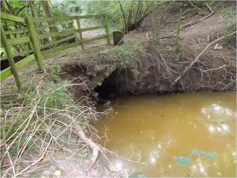
There are also three substantial earthwork dams located along the Baveney Brook. These are clearly visible on the LiDAR imagery. They were breeched long ago, but originally would have controlled a large water resource associated with a Tudor blast furnace that was located close to the southernmost dam near Furnace Mill where the brook turns to flow east. The tranquility of the Baveney Brook today hides the great industrial landscape that once dominated its valley.

Our volunteers Terry Chandler and Jennie Stanton (volunteers for North Worcestershire Archaeology, or Northwag) have been able to survey a stretch of the book starting at Wall Town Bridge to the northern boundary of the stream-walking project area.

Baveney Brook near Wall Town bridge
Near Wall Town bridge, the bed of the brook is rocky underfoot. As is the case for many of the streams in the Wyre Forest, they are susceptible to bank collapse and repairs are sometimes needed. Here local sandstone blocks have been used to reinforce the banks.
Repairs to the banks of Baveney Brook

Sandstone block repairs to Baveney Brook looking north

General view of Baveney Brook looking south showing bedrock
Terry noticed some unusual markings on some of the reinforcement blocks. Could these result from something dragging and scraping along the bank? Sometimes the towing of boats, such as canal boats, gauges lines into rocks or masonry along canals and  rivers, but this seems unlikely here in the shallow waters of a small stream. The stones may even have been re-used from elsewhere, so might not relate to any specific activity on the brook at this point. Any suggestions as to what these might be and when they were put in place would be welcome.


Further north is a stone-built weir. Traditional structures like this weir, constructed in stone, are important to conserve as they blend into the landscape so well and add to the local distinctiveness of the area. They are much more preferable to modern concrete structures for this reason. Concrete has a high carbon footprint and eventually will succumb to wear and tear much more quickly than stone. Since the original post we have had an explanation of the stone markings, offered by Rollo Gillespie. See *update at end of post

Weir on Baveney Brook
Weir on the Baveney Brook near Wall Town bridge

Weir on the Baveney Brook looking north
Unusual finds can turn up during a survey like this. Although not of archaeological interest, these crayfish claws seen on the banks of the stream (probably a leftover from the meal of an otter or a stoat?) are of note.

We think these are claws of an American signal crayfish, an alien or non-native crayfish which is invasive in the streams of the area, causing damage to the native crayfish population. Our next blog post will about the invasion of the American crayfish in the streams of the Wyre Forest.

*Update on the stone markings mentioned above, provided by Rollo Gillespie, so thanks to Rollo for contacting us and letting us know that this is a geological feature - "You are in the Wyre Forest coal area.  This is the imprint of the bark of the Carboniferous forest giant Calamites  which grew up to 30 or 40 metres tall.  It has a diminutive living relative called Mares Tails -- Equisetum arvense.".

All photographs are courtesy of Terry Chandler.

By Liz Pearson
lpearson@worcestershire.gov.uk; Google+

Wednesday 18 December 2013

Lem and Tanner's Brook - Ram pumps and boundary stones

The Lem and Tanners Brook form part of our survey from the junction of the Lem with the Dowles Brook, south to Clows Top. It passes mostly through farmland, and unlike the Dowles, there are no mills along this stretch, so there is much less likelihood of finding watermill or industrial structures within the stream banks than on the Dowles Brook. There are, nevertheless, some examples of industry in the vicinity.

Tanner's Brook, may, as the name suggests, relate to an historic tan-house along the brook, using its water supply. Reverand William Elliot in his Place names of Wyre Forest  has commented on this, pointing out a house on the brook named Tanners Bow. He also suggested that the Lem Brook means the clear brook, having the same derivation as the Leam which flows through Leamington. Perhaps the water didn't run as clear further south where the stream becomes known as Tanner's Brook. Tanning was a notoriously smelly and messy business! Gybhouse Colliery was located just to the east of Tanners Brook (and east of Bayton Common). It is thought to have been in production from 1867 to 1893.

Our volunteer for this stretch, Tony Leach, has found no evidence of these two industries but has photographed earthworks south-east of Bayton Common which are thought to be 20th century in date as they are shown on the 2nd Edition Ordnance Survey map but not the 1st Edition. The suggestion is that this was a colliery or gravel pit site but Tony believes that they are old clay pits, and that the clay was used to construct an embankment on the stream at this point as the banks show evidence of white/grey clay deposits. Does anyone know more about these earthworks? Any comments would be welcome.


Earthworks south-east of Bayton Common

Also recorded and photographed on Tanners Brook were an undated stone culvert, which is showing signs of collapse, and a bridge north of Badgers Walk.


Undated stone culvert 
Bridge near Badgers Walk

A boundary stone which is shown on some maps, was photographed on Tanners Brook on which you can see ?M, L on one side and R, L on the other.


Boundary marker stone, Far Forest, Worcestershire
Boundary marker stone inscribed 'M, L'
Boundary marker stone, Far Forest, Worcestershire
Boundary stone inscribed 'R, L'

It is most likely to be a property boundary marker - a private property marker or a dole stone, marking out land doled out to local residents. These were used to mark out parcels of land, and the initials represented those of the landowner or the registered land user. In this case it may mark the boundary of two plots of woodland coppice or pasture. A similar stone was found at Upton-on-Severn during flood alleviation works, which has also been interpreted as a dole stone, and also bears the letter M L.

The boundary stone is on the Shropshire side of the brook, so we just miss out on the opportunity to check the names of land owners and tenants through the Worcestershire Tithe and Inclosure maps online. Not that the stone necessarily dates from the same period.

Further downstream, on the Lem Brook, an old hydraulic ram pump was found. It bears the name Green and Carter Ltd, Vulcan Works.


Ram pump, Bewdley, Worcestershire
Ram pump on the Lem Brook

Green and Carter Ltd has been making and installing Vulcan and Vacher rams for over 100 years. These pumps are ideal for remote situations and are still an eco-friendly solution for pumping water. Even old pumps made before 1800 can be restored and brought back into use as the company still manufactures the parts. The company is also unusual in having all its records dating back to 1774, and from 1860 has every letter ever written or received by the company. This has helped with restoring old pumps (by identifying the model and the parts needed), an example being the restoration of ram pumps at the Lost gardens of Heligan in Cornwall.

Thanks are due to Tony Leach who surveyed this stretch of stream (all photographs are also courtesy of Tony Leach).

By Liz Pearson
lpearson@worcestershire.gov.uk, Google+

Wednesday 11 December 2013

A walk along the Dowles Brook

Since a meeting in June our volunteers have been out and about during the summer walking sections of the Dowles, Baveney, Lem and Tanner Brooks. We can only cover sections of stream that are under public ownership (such as Forestry Commission land) or where landowners have kindly allowed access.

In the Dowles valley only a small section of the lower Dowles Brook and a tributary in the upper Dowles, running through Wimperhill Hill Wood to Kingswood and Rotten Row, has been surveyed to date. The story so far for Dowles Brook is one of flood damage. This is perhaps not surprising considering the experience that Worcestershire residents have had in recent years with flooding from many sources – from our rivers, streams and even ground water which has escaped being channelled away by inundated drains, or simply has not been soaked up by soft surfaces.

Despite the relatively low level of ground in the Wyre Forest covered by hard surfaces such as roads, housing and industrial sites, the streams have not escaped the effects of flooding. Damage to the bridge near Furnace Mill on the Dowles Brook was seen by one of our volunteers, Pete Wolfe. It resulted from a large landslip, and other smaller landslips were seen along the Lower Dowles Brook. Carole Gammond and Jacqui Bradley encountered a few fallen trees on the tributary, and one here, close to the junction with the main Dowles Brook which was of some size. You wouldn't want to have been there when it fell.

Fallen tree on Dowles Brook tributary: Image courtesy of Carole Gammond and Jacqui Bradley
Large drifts of brushwood and debris have been seen previously by Pete Wolfe along the Dowles, which probably contribute to damage to structures and features in the banks by bank collapse and landslip.

Furnace Mill, Coopers Mill and Knowles Mill are important sites of archaeological interest along the brook which runs along the Worcestershire-Shropshire border. Furnace Mill was originally a blast furnace operating from the late 1500s until about 1600 AD. It later became a corn mill which operated until about 1920. Cooper's Mill may have its origins in the 13th century, but is known to have fallen out of use by around 1898. Knowles Mill still survives, with much of its machinery (possible 18th century) intact, although the original date of the mill is unknown. For further information on this and other mills along the Dowles, see Mills on Dowles Brook and its tributaries by Tim Booth for Wyre Forest Study Group Review. The review has also reported on Floods in the Dowles Valley in 2007, an event which resulted in bridges being swept away and much damage to Furnace Mill.

We have yet to take a good look the stream banks at the mill sites to assess whether there are remains of structures or old water channels, but it is clear that the archaeology along this brook is very vulnerable to damage and destruction by flood damage. Valuable information could be lost at any time, and unfortunately little recording of the known archaeology here, such as the mills, has been undertaken, although North Worcestershire Archaeology Group (NorthWAG) have carried out work at Knowles Mill. As most archaeological recording is undertaken as a result of commercial development, archaeological knowledge is limited for the Wyre Forest. Nevertheless, local groups with an interest in local history and archaeology are becoming increasingly successful at undertaking such work with the advice and supervision of professional archaeologists through Heritage Lottery funded projects (or similar). For further examples of such work see the Hanley Castle Community Archaeology project and the Digminster community archaeology project at Kidderminster. 

Knowledge has about the archaeology of the Dowles valley and a large area of the Wyre Forest has also increased as a result of an archaeological project funded through the  Grow With Wyre initiative  -see the Wyre Forest Interactive Lidar (Light detection and ranging) website. Volunteers have helped with this project, and as a result you can explore the landscape of the Wyre Forest and its setting through this web site.

Our recommendation would be to continue with the present work to cover stretches of stream not yet surveyed, but also to encourage more detailed non-destructive survey and recording of any surviving remains relating to the known sites through local community archaeology projects. Stabilising the banks around particularly important structures may be worth considering, although the effect on the local hydrology would need to be considered.

To illustrate the importance of archaeological remains which can simply fall out of the stream or river banks, consider the find that one of our staff at Worcestershire Archaeology encountered in March 2013 following the aftermath of floods resulting from rain and snow melt. We were contacted by West Mercia Police after they were alerted to the find of a skull fragment lying by the bridge at Eckington on the River Avon by a dog walker. Nick Daffern went along to investigate. The find was judged to be most likely archaeological, and after radiocarbon dating, was confirmed to be Neolithic in date. The story made the national papers. On the other hand, survival of archaeological remains in river banks can defy expectations. A medieval quay at Hanley Castle on the River Severn was known from documentary sources but presumed to have been destroyed by dredging or flood damage. It was, in fact, found to survive after a diving mission. The quay was found, complete with broken pots - presumably waste from loading and unloading of goods at the quay. For further information on both incidences see the links below.

We are grateful to Pete Wolfe, Carole Gammond and Jacqui Bradley for donning the waders to stream-walk along the Dowles valley.

By Liz Pearson
lpearson@Worcestershire.gov.uk,  Google+

Useful web pages:


Tuesday 11 June 2013

Introduction meeting


The project kicked off with a meeting to introduce the survey methods to the volunteers. We met on-site at Woodlands Park, Northfield, in Birmingham. It might seem a little odd to meet in Birmingham when the project is based in the Wyre Forest. The reason for this, seemingly, unrelated venue was to view an unusual streambank feature that most would not have come across before – a prehistoric burnt mound. These are found scattered all around Birmingham and much of the West Midlands, so we are hoping to find some in the stream banks of the Wyre Forest.

Group meeting in Northfield, Birmingham: Courtesy Terry Chandler


Birmingham City Archaeologist, Mike Hodder, was on hand to talk more about these enigmatic features. They can be visible in stream banks as thick lenses of burnt stone and charcoal. Archaeologists have interpreted these in a number of ways in the past, but the current thinking is that they are likely to be the residues of sweat lodges (a simple version of a sauna or steam room). This is based on experimental work and on parallels seen with native societies, such as North American Indian groups, who were using structures like these until recently (or still are). If you see something like this...... 

Burnt stream deposits: Courtesy Terry Chandler


Burnt mound stream deposits: Courtesy Mike Hodder

in the banks of a stream you probably wouldn't think anything of it. After all, you can see lenses of cobbles in any stream bank, especially if you are in there wading around in your wellies! What makes them different, if you look closely, is that the stones are all angular, shattered pebbles and usually the soil around them is black with charcoal. It is the dowsing of hot cobbles (burnt on a fire) with water that, we think, creates these residues of heat-shattered stone and charcoal.

Heat-cracked stones: Courtesy of Mike Hodder, Birmingham City Archaeologist

 We might have looked an odd group, standing at the stream banks in the park, all peering closely at a fist full of pebbles: but all with a purpose. Being able to recognise these features is important – we don't want to miss them. They have a story to tell that goes beyond showing us evidence of the prehistoric version of the communal baths. The burnt mounds are mostly mid-Bronze Age in date, and they alert us to where these settlements were, but also amongst the pebbles and dirt is also a store of information on the past environment. The charcoal shows us what trees, or wood, was around locally to be burnt. Was that alder, hazel, or oak? Wet peaty material often survives with burnt stone and charcoal, and from this we can analyse pollen and seed remains to reconstruct the surrounding Bronze Age environment. More information on prehistoric burnt mounds in Birmingham can be found here.


Burnt mound at Clifton Quarry, Worcestershire
Here is an example of a burnt mound that was revealed during excavation of a sand and gravel quarry at Clifton in south Worcestershire. It is usually only when large areas of ground are exposed at once that we see an entire burnt mound, so it is mainly in quarries or for example, along road developments that they appear.

Nevertheless, stream-walking has proved successful for finding many sites in the Birmingham area, and what you see is the section where the stream has scythed through the mound. We don't know whether we will find any evidence of burnt mounds in the Wyre Forest, but who knows…….

We also went on to talk about other archaeological evidence that might be found in the Dowles, Baveney and Lem Brooks of the Wyre Forest: evidence of mills, kilns, bridges, revetments, fish weirs and old stream channels meandering across the path of the modern stream. Streams have been busy places in the past, often hives of industry on a small scale. To find it, as Mike Hodder says, you have to get in there, look closely, lift up the bankside vegetation…but watch your step.
 
Liz Pearson                                                                                                     


Hello and welcome

Worcestershire Archaeology is working with volunteers on a stream-walking survey of the Dowles, Baveney and Lem Brooks within the Wyre Forest Landscape Partnership project area (resulting in approximately 17 km of watercourse surveyed). The aim of the survey is to record archaeological evidence for structures, fords, relict stream channels or prehistoric burnt mounds. The type of structures we hope to find could include, for example: mills, kilns, bridges, revetments and fish weirs, which we anticipate will be visible mainly in the form of worked stone, timbers or brickwork. We are also interested in evidence for relict stream channels and burnt mounds which are likely to be visible as organic deposits, charcoal and burnt stone in the stream bank.
Burnt mounds are something that may be unfamiliar. We find them archaeologically, usually associated with watercourses, and commonly in the West Midlands. They are prehistoric in date (Bronze Age to Iron Age) and consist of mounds of burnt, heat-cracked stone and charcoal. There is some debate about what they are, but the general consensus is that they are most likely to be the remains of sweat lodges (more explanation will be forthcoming in future posts).
This work is important as streams, and their associated archaeology, are very vulnerable to flood damage, and we've been no strangers to the affects of flooding this past winter! Increasingly our watercourses are also being affected by flood prevention engineering works, so this allows us to assess the character of the stream-bank archaeology in advance of any work taking place. This is a small pilot project designed to test and refine our survey methods.

The work is funded by the Forestry Commission, and is led by Worcestershire Archives and Archaeology Service. The project leader is Liz Pearson (lpearson@worcestershire.gov.uk).